
eurekahistory.com is an interactive map based website that allows users to explore information about Eureka’s local history and architecture, as well as contribute their own information. The site was developed in partnership with Development Services staff and Eureka’s Historic Preservation Commission and was funded by a grant through the State Office of Historic Preservation.
This site is meant to both educate the public about the variety of historic resources in Eureka and also create a way to take part and contribute to Eureka’s story. Through this site, the intention is to build on Eureka’s strengths and showcase Eureka’s historic structures as one of its largest and most unique assets.
The site is built around a diverse map with roughly 1,500 structures to explore. If you’re interested in William Carson, or Queen Anne Architecture, or buildings built in the 1860s, you can filter the site to find that information. You can also search for tours of interesting sites that all have a similar theme or location, such as properties on Hillsdale Street or local theaters. Much of the information in the site is architectural information, but it is also the intention of the site’s creators to include interesting local stories of the people who lived here.
The majority of the information housed in eurekahistroy.com so far is inspired from “Eureka: An Architectural View”, also known as “The Green Book”. This resource is the most comprehensive historic inventory created to date and was undertaken by the Eureka Heritage Society in the 1990s. A huge thank you to the Eureka Heritage Society for their efforts and their generosity in sharing this information with our community.
Community members can create user accounts and add information to individual sites by adding written content and well as pictures, audio, and video. The public is encouraged to create user accounts, and contact the Development Services Department at the City of Eureka to learn how to set up an account and become a contributor. All information added to the website form the general public will be reviewed by the Historic Preservation Commission prior to being published to ensure information is historically accurate.
 Permissions, Orientation, and Legend
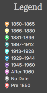
Please allow the site access to your location information to drop a “You Are Here” pin on the map. This will help orient you if you are unfamiliar with the city. We use this data for no other purpose. The map pins are color-coded by date; refer to the legend on the left.
Clusters
Clusters represent multiple points in close proximity to each other. The number shows how many points are contained in the cluster, and they are also color-coded by how many points are collected in a cluster. When you click a cluster, the map will automatically zoom to the cluster area.
How to Contribute
Your comments are always welcome on any historic place, using the comments section displayed for each place. However, if you would like to create new places or contribute more information about historic places, please sign up to be a contributor by following this link.
Acknowledgements
This site was created with support from the California Office of Historic Preservation and the National Park Service. Made by Biztech.